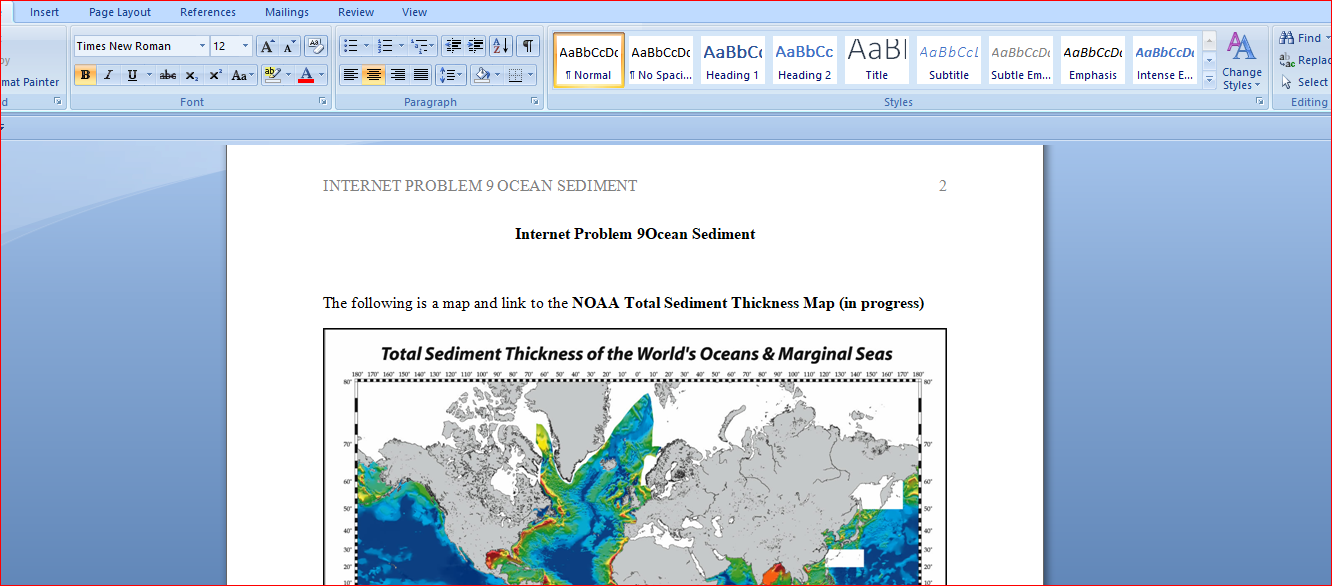
Describe the locations of at least two areas on the map were the seafloor sediments are thickest.
Describe the locations of at least two areas on the map were the seafloor sediments are thickest. The map is from NOAA's National Geophysical Data Center is constructed using ocean core data and seismic reflection profiles showing the thickness of the sediment “sitting” on top of the oceanic crust (or continental crust along continental margins). You should remember that the map in IP1 was a map showing the age of the basalt oceanic crust. This total sediment thickness map shows the thickness of sediment deposited on top of the igneous (basaltic) oceanic crust.
1) As shown on this map, what is the maximum thickness of the sediment on the ocean floor?
2) Describe the locations of at least two areas on the map were the seafloor sediments are thickest.
3) Are these locations, near the continents or on the deep ocean floor?
4) In contrast, where are the sediment thinnest, near the continents or on the deep oceans?
5) From your reading, is there a logical reason for the general location of thick sediment deposits relative to thinner sediment deposits? Explain why.The western margin of North America is a transform fault/convergent plate boundary
between the Pacific Plate made up of oceanic crust, and the North American Plate
made up of continental crust. The transform fault plate boundary runs for the Gulf of
California (Sea of Cortez) north to Mendocino, CA. North of the “Mendocino Triple
Junction” into Oregon, and Washington, there is a convergent plate boundary with the
oceanic trench of the Juan de Fuca and Gorda Plate junctions, located offshore. The
associated volcanic (magmatic arc) making up the northern Pacific Coast Range,
Including Lassen Volcanic Park in California and the volcanic mountains of the Cascade
Range.
The eastern Atlantic margin of North America and The Gulf of Mexico are passive
continental margins. The east coast of North America was at one time located at a
divergent plate boundary (180 mya) but now lies well within the North American plate.
The Gulf of Mexico is a “failed rift” basin.
More on the Geologic History of the Gulf of Mexico:
http://www.geoexpro.com/
the thinnest sediment accumulations?7) Which of these three coastlines has the thickest sediment accumulations?
8-9) Formulate a hypothesis based on Plate Tectonic Theory which explains the
difference in sediment thickness along these three coastlines.10) At the top of the maps of the map*, the white areas in the Arctic Ocean
indicate there is no data for this area. Is there a logical explanation for why there
is no data for the Arctic Ocean Basin?*Note: The area at the top and bottom of the map appear much more extensive than
they are in comparison to other geographic areas closer to the equator. The geographic
distortion is due to the type of map projection used to “flatten” the spherical geographic
information to a two-dimensional map.
More on Map Projections:
http://www.colorado.edu/
Answer preview for Describe the locations of at least two areas on the map were the seafloor sediments are thickest.
Words: 525